If you’re trying to figure out which parts of China are the reddest, you should jot Chishui down on your list. The city boasts red land, red water and red history. The red history comes from the Battle of Chishui River, when Communist forces on the Long March in early 1935 outmaneuvered their Nationalist foes by crossing the river, recrossing the river, and then recrossing the river two more times. The red water comes from the fact that the Chishui River is so rich in sand that it takes on a reddish hue – its name literally means “red water.” And the red land is symbolized by the spectacular red stone landforms that tower over the landscape.
In the northwest of Guizhou Province, bordering Sichuan, Chishui sits where the Yunnan-Guizhou Plateau eases down into the Sichuan Basin. It is surrounded by mountains and valleys filled with distinctive purple-red soil and is spliced in two by the Chishui River, which is also famous for being the center of production for China’s iconic liquor, Moutai.
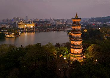
The city has a just-built feel, with new hotels, residential blocks and a promenade along the river. Thanks to the tireless efforts of the city’s tourism bureau to get in on the “red tourism” trend and its connection with the iconic Long March, money has clearly been flowing in. If you want to see what a city looks like as it moves into moderate prosperity, Chishui is a good example.
But Chishui’s urban core isn’t the attraction here. While its tourism industry is developed enough to provide modern, clean hotel rooms and places to grab a decent meal and indifferent cup of coffee, it’s primarily a jumping-off point to the area’s natural beauty and points of historic interest.
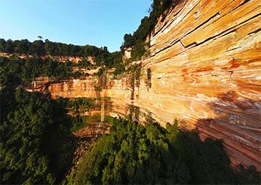
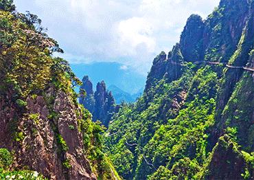
About one hour’s drive outside of town are the stunning red rockfaces known as Danxia. Dating back some 80 million years and sprawling across China in a crescent from southwest to southeast, the six major Danxia landforms boast of steep, red sandstone cliffs thanks to millennia of erosion. Their unique landscapes earned a place on the UNESCO World Heritage List in 2010. The section in Chishui is the largest and is considered the most impressive. You can enjoy all kinds of natural beauty – huge red cliffs and lofty terrain spotted with magnificent, odd-shaped rocks, imposing isolated peaks and deep gorges with 350 tumbling waterfalls, and lush primeval forests of bamboo and tree ferns that provide a sanctuary to endangered animals. The whole area resembles a piece of jewelry studded with emeralds and rubies, or a slice of red velvet cake wrapped in a green ribbon.
The 1,200 square kilometers of Chishui Danxia has developed a Key National Scenic Area, Cyathea National Nature Reserve, Zhuhai National Forest Park, Swallow Rock State Forest Park, and Subtropical Evergreen Broadleaf Forest Nature Reserve. It is impossible to see everything on a short trip, but visiting the most famous three scenic spots in the Chishui Danxia Tourism Area, the core of the scenic area is doable in two days, visiting the Buddha Light Rock, the 76 meters Great Waterfall, one of the biggest in China, and Swallow Rock.
The Buddha Light Rock is perhaps the most beautiful spot, reputed as “the crown jewel of Danxia.” The spectacular curved cliff made of layers of red and brown sandstone is more than 1,000 meters wide and 300 meters high. In the middle, a 200-meter-high and 40-meterwide waterfall spills down. The best time of the day to visit is the afternoon, when the light shines on the red rock and gilds the whole mountain.
Swallow Rock, you may be shocked to learn, is inhabited by thousands of swallows that dive and swoop overhead. You can take a cable car up to the curved rock, tucked high at the top of a hill. It is thought to have been the home to Neolithic communities and was even inhabited until the 1930s. It too boasts a stunning waterfall.
Each scenic spot takes about three hours to see. They’re all walkable, with well-built paths and steps, and though they require a decent level of fitness there are plenty of places to stop and enjoy the atmosphere along the way.
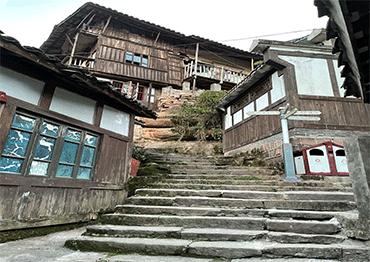
On the way back from your scenic exploration to the city of Chishui, you can stop by Bing’an Ancient Town. The small town was built for defense, hugging a mountain on one side and embraced all around by the Chishui River. It was a hub for commerce between Sichuan and Guizhou provinces during the Ming and Qing dynasties (1368-1911), as well as an important military outpost. Now, it’s another special thing, an ancient town that hasn’t yet received a commercial facelift.
Its dock that was once bustling with boats ferrying wealth up and down the river is quiet now. The narrow stone streets are heavy with memories, winding up and down through the town. Most of the wooden houses stand on stilts to separate them from the damp earth below, a common feature of traditional architecture in humid, rainy Guizhou. The outer walls are layered with a mixture of wooden boards, bamboo, and soil, with dark green moss climbing up many walls. Many windows and doors have fallen into disrepair and in some places windows stand missing panes of glass or are covered by makeshift plastic tarps.
It is easy to feel the simple lives of residents. Elderly locals murmur to each other as they take after-meal strolls. The village’s kids play raucous, screaming games in the town’s small central square. On one side of the square, a striking red star hangs above the door of the humble building that hosts the local Party branch and neighborhood committee.
It’s a bit hard to imagine how busy Bing’an was just 100 years ago. As a testament to its one-time importance to local trade, it’s connected to the outside world by a 32-meter stone bridge with two carved dragons that stretches over the Chishui River. It was built in the Ming Dynasty and used to be the biggest crossing in the area. Now the dragons’ faces have been weathered away and the bridge can only support pedestrians, not the laden carts that once used it. A slogan painted on the wall of a time speaks to another bygone era, though one only now passing from living memory. The phrase “overthrow local despots, distribute land” is a quiet reminder of the land reforms that swept China starting before the founding of the People’s Republic.
Bing’an has its place in the events which brought about the modern State, and is a site for red tourism itself. A modern suspension bridge that spans the torrents is decorated with dozens of red flags. A plaque nearby commemorates the decisions made by the Red Army Corps. It was here that Mao Zedong in 1935 decided to begin the rapid campaign that allowed his forces to escape Nationalist encirclement and continue on the journey that concluded in Yan’an in Shaanxi Province, changing the course of history.