elow the Yangtze River’s surface, stone carvings preserved in an underwater museum are providing scientists with rare windows for studying climate change.
Engraved on the 1.6-kilometerlong sandstone outcrop of Baiheliang are some of the oldest hydrological records in the world. Previously visible during the dry season from December to March, the markings located in Southwest China’s Chongqing have been submerged year-round since the completion of the Three Gorges Reservoir in the early 2000s.
Among the centuries-old calligraphy and poems engraved into the rock are carvings of fish. These marked the lowest recorded levels of the Yangtze, and were the subject of local folklore and myths.
The carvings on Baiheliang – which translates to White Crane Ridge – provide 72 data points of low water levels covering 1,200 years, from the year 764 during the Tang Dynasty until 1963. This data was used in 1992 for the design of the Three Gorges Dam, the massive hydroelectric project that changed the face of the region’s geography.
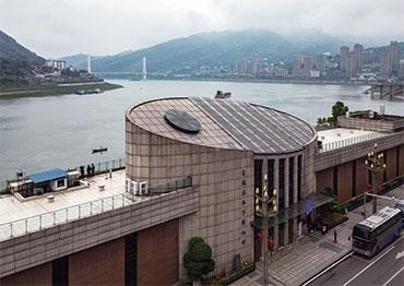
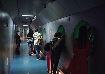
In 2008, the Baiheliang ancient hydrological inscription was included in the Tentative List of the World Heritage of the UNESCO. After seven years of construction and a cost of 193 million yuan (US$30m), Baiheliang Underwater Museum opened to the public in May 2009. One of a kind, the museum includes a tunnel that goes below the Yangtze River’s surface with portals to view the ancient carvings, now 40 meters underwater.
Similarly, ancient Egyptians built large gauges called nilometers to measure the water levels of the Nile during the annual flood season to forecast harvest and tax revenues for the next year. The Ar-Raoudha nilometer in Cairo, built in 861 during the Arab period, joined the UNESCO World Heritage Tentative List in 2003.
Speaking with NewsChina, Yang Bangde, curator of Baiheliang Underwater Museum, explained why China is promoting a campaign to apply for joint World Cultural Heritage status with Egypt for their hydrology records, and what the information they hold means for China and the world today.
CNS: What makes the Baiheliang inscription unique from the nilometers?
Yang Bangde: Folklore has it that white cranes were often seen flying and playing above Baiheliang in ancient times, hence the name. Engraved on the ridge are 165 sections of inscriptions, 18 fish, two Guanyin bodhisattvas, and one white crane. Among them, 108 sections are of great hydrological value, containing 72 measurements starting in the year 764.
As a local proverb goes: “The sighting of the stone fish carvings promises a good harvest.” Since the Tang Dynasty (618-907), the ancients referenced these fish figures to mark dry-season water levels, a unique practice among the world’s major river basins. It provides physical evidence to study the hydrological conditions of the Yangtze River, as well as historical patterns of regional and global climate change.
Based on the analysis of this hydro-logical data, ancient Chinese calculated a 10-year wet-dry cycle, with the surfacing of the stone fish indicating the end of the dry cycle and a coming year of ample rainfall and good harvests.
Ancient Egypt’s Nile River Basin is among the world’s first where water levels were monitored, dating back over 5,000 years with existing records dating back more than 1,300 years. Priests of the Egyptian temples invented structures to measure the flood levels of the Nile, later known as nilometers, which helped determine how much tax should be paid based on the correlation between the water level and the harvest (too little water, or too much on the alluvial plain, would indicate a poor harvest to come).
There were at least 20 nilometers along the Nile. Records were kept in the archives of palaces and temples. The nilometers come in three forms. The first is a vertical column submerged in the river, with inscribed marks of water levels. The second is a stairway leading into the river, with marks of water levels inscribed on the walls on both sides. The third is a well built in a temple on the river bank, which collects the river’s water through a long channel or culvert.
CNS: Why is Baiheliang joining nilometers in applying for UNESCO World Cultural Heritage status?
YB: China and Egypt both host hydrological heritage with existing physical relics of water level observation. China’s Baiheliang inscriptions in Chongqing and Egypt’s nilometers are located along two of the world’s greatest rivers. And these relics both manifest the importance of river resources for two agricultural civilizations on different continents.
There are especially close connections between the Baiheliang and nilometer inscriptions. Both are relics and testimony of the longest-enduring human-water relationship in the ancient world, representing the wisdom of early agricultural civilizations in water level measurement and water utilization, and offer detailed scientific information on climate change over thousands of years. The joint application will help promote exchanges and mutual learning among civilizations, and develop a new model for world heritage conservation.
In 2021, Peking University’s School of Archaeology and Museology and UNESCO’s World Heritage Institute of Training and Research for the Asia-Pacific region completed two research projects on the Baiheliang inscriptions, and embarked on the feasibility study for a joint application.
Preparations for the joint application are underway. Baiheliang Museum is establishing a work mechanism for governmental and non-governmental cooperation with the Egyptian side. Now Baiheliang, which has been included in the China UNESCO World Heritage Tentative List, needs to submit its application request, refill application forms and hand in relevant information, and improve its own application text, as well as communicate with the Egyptian side to work on the joint application text as soon as possible.
CNS: What is the importance of the Baiheliang artifacts and what has China done to protect them? What lessons does this offer the world for underwater cultural heritage conservation?
YB: In addition to their hydrological value, the Baiheliang inscriptions boast important historical and artistic value. They are also known as “the underwater forest of calligraphy steles.” The ridge is inscribed with calligraphy of various styles left by the literati since the Tang and Song dynasties, and are treasured in China’s calligraphy and stone inscription arts. Containing over 10,000 inscribed Chinese characters, Baiheliang has become a unique embodiment of Chinese arts.
The Baiheliang inscriptions were introduced to the world in 1974 at an international conference held in Paris [International Conference on the Results of the International Hydrological Decade and on Future Programs in Hydrology, jointly organized by the UNESCO World Meteorological Organization and International Association of Hydrological Sciences], and drew much attention from experts. As the Three Gorges project would submerge the stone ridge, conservation of the inscriptions became a key issue for discussion and research among experts.
Among the proposals to preserve the site, the “depressurized container” proposed by Ge Xiurun of the Institute of Rock and Soil Mechanics of the Chinese Academy of Sciences, was chosen. The plan was to build a huge container on the site of the ridge and fill it with filtered Yangtze River water to match external water pressures. The container utilizes advanced technology and activated carbon to purify the Yangtze water, to reduce erosion of the inscriptions.
A channel was built along the Baiheliang ridge inside the container. Visitors can view the underwater inscriptions up close through the observation windows in the channel. The project is one of the most challenging and most technically diverse projects to date, making the Three Gorges area the world’s largest cluster of dry-season inscriptions, and the world’s first museum of underwater inscriptions.
Countries around the world are paying more attention to underwater cultural heritage than ever, with Egypt, Greece and Mexico planning to build underwater museums. In China, an array of underwater relics, such as the stone carvings in the Shimen Reservoir [in Shaanxi Province], the ancient cities of Chun’an and Sui’an [under the Xin’an River Hydraulic Power Station in Zhejiang Province] and the Xifengkou section of the Great Wall [submerged in the Panjiakou Reservoir in Hebei Province], are also undergoing preservation efforts. Baiheliang’s protection and utilization of underwater heritage opens a new perspective for the world.
CNS: With extreme weather events on the rise, including droughts and floods, how can Baiheliang’s 1,200-year history of hydrological monitoring contribute to the world today?
YB: Throughout human history, major disasters such as extreme droughts, floods and low temperatures have had significant impacts on socio-economic development.
The hydrological information recorded on the Baiheliang ridge represents the ancients’ empirical knowledge acquired through long-term observation, which implies the causal connection and scientific patterns among climate, hydrology and agriculture. It summarizes precipitation cycles and water level changes in the Three Gorges area of the Yangtze River. These records provide valuable historical information for the study of agricultural production in the Three Gorges region in ancient times, and still provide references on climate change and water issues today.
Baiheliang’s hydrological information is important for the study of hydropower development, bridge construction, inland navigation, farmland irrigation, urban water supply and flood control along the Yangtze River Basin. It offered accurate and reliable hydrological data for the planning and construction of the Gezhouba Dam and the Three Gorges Water Conservancy Project.
In the planning of a huge water conservancy project, it is necessary to make sure that it can withstand any once-in-a-millennium extreme drought or flood and maintain its power generation and navigation facilities. The Baiheliang inscriptions provide hydrological information on the Yangtze River covering more than 1,000 years, which can serve as a basis for engineering such projects.
Climate and hydrological conditions are closely related. Now, extreme weather is occurring much more frequently, which has led to increasingly severe natural disasters. The hydrological information of Baiheliang shows that the upper reaches of the Yangtze River experience a minor dry cycle every three to five years, a severe dry cycle every 10 years, and an extreme dry cycle every 600 years. The studies on whether these hydroclimatic patterns are still relevant today and may provide some ideas for humanity to tackle extreme weather in the future.

 Old Version


